Werribee · Laverton · Williamstown · Sandringham
Cross-city services begin Sunday 23 August 2026
–days
–hours
–mins
Werribee · Laverton · Williamstown · Sandringham
Cross-city services begin Sunday 23 August 2026
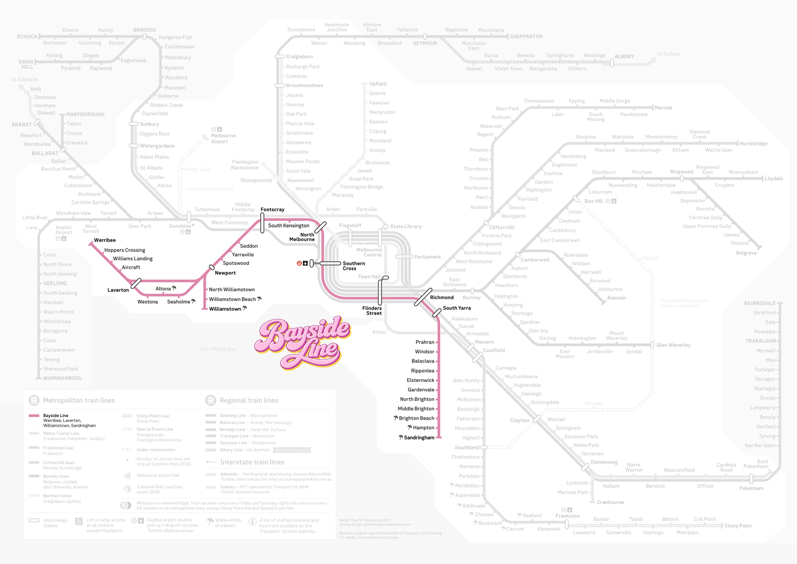
From Werribee in the west, around the top of Port Phillip Bay and through the city to Sandringham in the south‑east. Here's the Bayside Line on the network map — on its own, or with every other line for context.
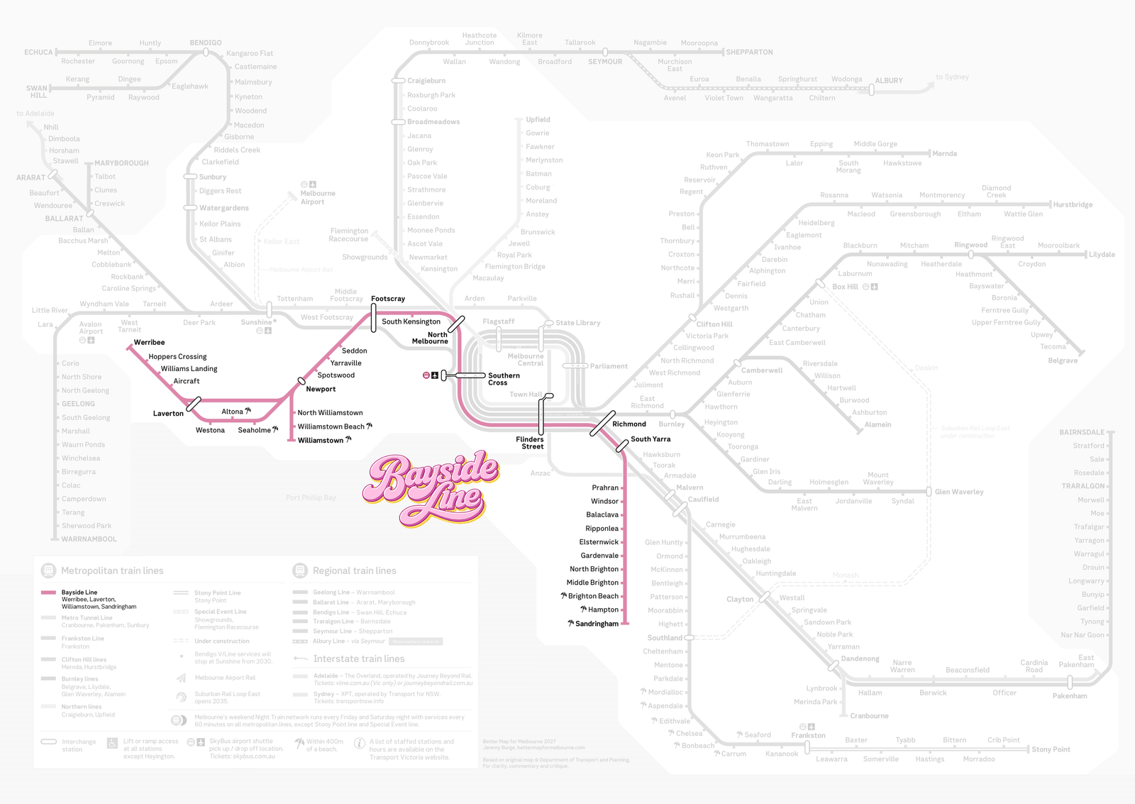
⬇ Download the Bayside Line map (high‑res PNG)
Tap any station on the stylised map to see beaches, connections and local highlights — look for the umbrella 🏖 stations right by the sand.
Seven stations put you within a short stroll of the sand — on both sides of the bay. No car park required.

Calm, shallow water, a long timber pier and the Esplanade café strip. One of the west's best-kept secrets, two minutes' walk from Altona station.
A proper swimming beach with a 1930s pavilion and the Williamstown Swimming & Life Saving Club — 400 m from the station that shares its name.
Gem Pier, Seaworks, city ferries and the best fish and chips in the inner west, with skyline views across the water.
The famous 82 bathing boxes at Dendy Street Beach, plus Green Point and a swimmable stretch of bay right off the platform at Brighton Beach.
A wide, sandy family beach backed by the Hampton Street shopping village — ice cream on the way down is compulsory.
Village shops and beach at the line's end, with cliff-top walks to Half Moon Bay and the wreck of HMVS Cerberus a little further south.
Not a beach day? The line also serves Scienceworks (Spotswood), the Sun Theatre and Yarraville village, Footscray's food scene, Prahran Market, Rippon Lea Estate (Ripponlea) — and Werribee Park Mansion and the Open Range Zoo are a short bus ride from Werribee.
Werribee to Sandringham, the long way round the bay. Tap a row to see it on the map.
| Station | Section | Beach nearby | Connections |
|---|
From Sunday 23 August 2026, the Werribee, Laverton and Williamstown lines join with the Sandringham line to form a single cross-city service. Instead of terminating in the city, most trains from the west continue through Flinders Street and out the other side to Sandringham — and vice versa. No more changing trains in the Loop to get from one side of the bay to the other.
The change is possible because the Metro Tunnel moved the busiest lines into their own tunnel, freeing up space through the core of the network. The new timetable adds more than 180 extra weekly services across these four lines, with cross-city trains running every 10 minutes between Newport and Sandringham on weekdays.
One exception to know about: in peak periods, express trains from Werribee terminate at Flinders Street rather than continuing across the city. Stopping-all-stations services carry the cross-city pattern through the peaks.
Stopping services run cross-city via Newport and Flinders Street — the core Bayside Line pattern.
Peak expresses from Werribee skip stations on the way in and terminate at Flinders Street.
Altona Loop services via Westona, Altona and Seaholme join the cross-city pattern at Newport.
Trains from the Williamstown branch run through the city to the bayside south-east.

A stylised map of the whole line — every station, every beach umbrella — in full retro glory. Download it, print it, stick it above your desk.
Want it on a t-shirt instead? The Express Transit store has you covered.
Official timetables live with Public Transport Victoria. The new cross-city timetable applies from 23 August 2026.
Bayside Line is an unofficial name for these services — on official maps, apps and station screens you'll see them listed by their traditional line names.
Melbourne's new cross-city service deserves a name. Four line names for one continuous train is a mouthful — and “the Werribee, Laverton, Williamstown and Sandringham lines” doesn't exactly sing. This service hugs Port Phillip Bay from the west to the south-east, serving more beaches than any other line in Melbourne. So: the Bayside Line.
The name is part of a wider push for clearer transit maps and wayfinding in Melbourne. See the full network reimagined at Better Map for Melbourne, where the Bayside Line takes its place alongside sensibly named friends.
Bayside Line is a campaign by Express Transit.